Introduction
On my last trip to Japan, I was using Google Maps to get around. It took me a solid week and change before I discovered some things about Google Maps that I wished I had known before my trip. So I’ll give you some tips that I’ve learned to help you the next time you go to Japan. As an example, let’s try to take the subway from the Andaz Tokyo to Jiro’s.
Initial search

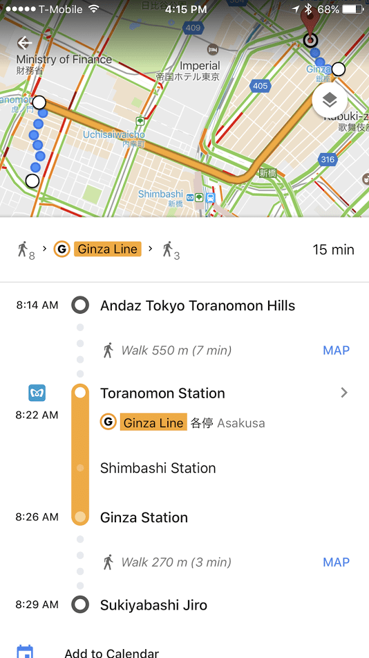
Okay this page is jam-packed with info so let’s spend time talking about it. Essentially this says it’s going to take you 15 minutes by subway to get to Jiro’s. It’s going to take you 8 minutes to walk to the Toranomon station, then you’ll ride the Ginza line, and then you’ll walk 3 minutes to Jiro’s. You will also take the 8:22AM train and it’ll cost you 170 yen.
Drill down one screen

Once you click on the first route, you’ll get this next screen. This gives you more detailed information. The blue dots are your walking path. The yellow line is the Ginza subway line. The key info that you’re getting on this screen is that you’ll be taking the Ginza line to Asakusa and that the Ginza stop is in 2 stops. This is very important because once you get to the Toranomon station, you won’t know which DIRECTION train to take. So you should look at the posted signs to look for the train headed to Asakusa. If you don’t see that, you’ll see a poster with all the train stops on it. Find Ginza on the poster! If you don’t find Ginza, that means you’re going in the wrong direction.
Clicking on ‘2 stops’
If you click on ‘2 stops’, you’ll get this screen. This screen is helpful in case you can’t find Asakusa on the posted signs. This tells you that you need to get on the train that is headed to Shimbashi and then Ginza. THERE WILL BE TIMES WHEN YOU DON’T SEE ASAKUSA AND YOU’LL BE LOOKING AT STOPS. You’ll then see posters that look like this! So walk up to that poster and look for Shimbashi and Ginza. They should be at the top or bottom of the poster (not the middle) since they are the next 2 stops!
Ride the subway to your stop and then what?

This is the part that annoyed me the most and took me a week before I discovered it. The screenshot above is when I tapped in “Map” at the Ginza stop from the first screenshot. This shows me how to walk to Jiro’s once I get to the Ginza station. However, stations in Japan are HUGE. And they can have over a dozen exits, so you’ll want to know which exit will get you closest to Jiro’s. After a week of just guessing and trying to get up to the surface as quickly as possible, I had my AHA moment!
Zoom into the subway station

When you zoom into the Ginza station, do you see the little letters A7, A8, A9? Well, that’s the subway exit you want to take! BOOM! So now when you get to Ginza, look up at all the exits and find the one that says A9 and exit out of that one. You’ll now be at the surface and can walk to Jiro’s.
One last protip
One last tip before I’m done. It took me a while to figure this out, but let’s say once you take the A9 exit and are now outside, which direction should you go in? Sure you can look for building markers and streets, but there’s an easier way. In the iPhone at least, there is a built in compass. If you stand still and rotate your body, you’ll notice the arrow in the blue dot above will move with you! YASSSSSSSSS! So keep rotating yourself until the blue arrow is pointed towards the direction the map wants you to go and walk in that direction!
Awesome tips, I also have TMobile, how was the 2G there? No need for pocket wifi?
Adequate. Videos won’t load but maps and mostly images work
The last two points were really useful. Thanks!
We did the same thing in Hong Kong and just guessed at the metro exits. I didn’t know you could zoom in, so thanks for that. And to determine which direction you need to go most metro systems are setup so that the last station is noted above the train. Bangkok is this way and so many people get confused. But their little ticket purchasing machine is so easy and intuitive to use since you just press the station you want to go to and it tells you how much to insert. And just follow that till the end to determine which direction you need as well. Super basic and easy.
Zooming in for station exits works in most of Asia’s amazing subway systems! I rely on it heavily in Japan, HK, and Taipei.